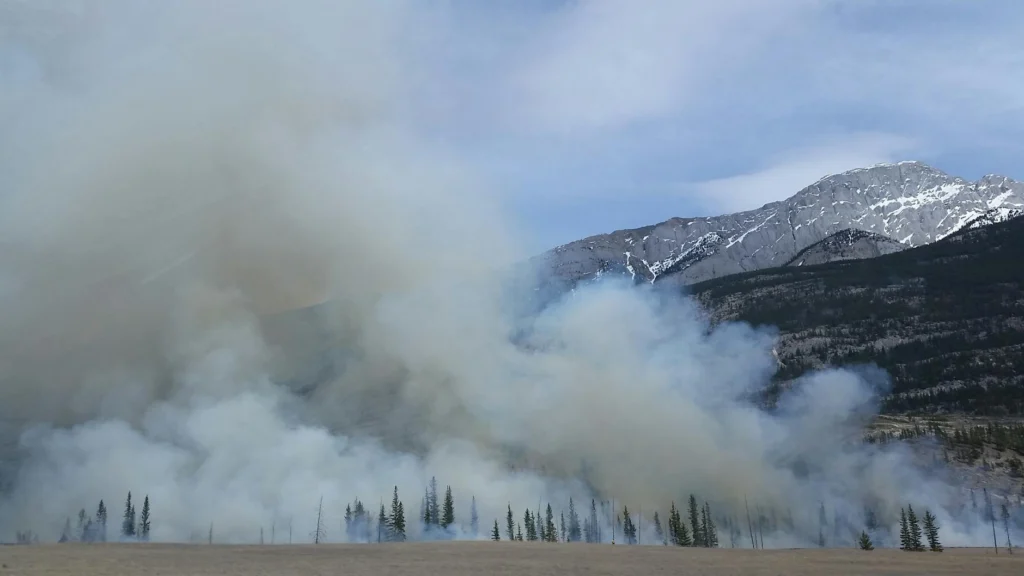
When a wildfire grows large enough, something remarkable happens: it stops being controlled by the weather and starts controlling it. The fire generates its own winds, spawns its own thunderstorms, and can even create tornadoes. Understanding these wildfire spread dynamics is the key to understanding why megafires have become so devastating, and why our models keep underestimating them.
In 2023, Canada experienced its worst wildfire season in recorded history, with 15 million hectares burned[s], more than double the previous record. Australia’s Black Summer of 2019-2020 burned over 26.4 million hectares[s] and produced fire-generated thunderstorms that injected smoke into the stratosphere with the force of a volcanic eruption. These are not ordinary fires. They are weather systems.
How fire creates its own wind
Every fire generates rising hot air. That much is intuitive. But what happens next is a fluid dynamics problem. As hot gases rise, they create a low-pressure zone near the ground. Surrounding air rushes in to fill the void. This inflow of fresh, oxygen-rich air feeds the fire, which burns hotter, which creates a stronger updraft, which pulls in more air. It is a positive feedback loop.
A 2025 paper in PNAS Nexus gave this process a formal name: wildland fire entrainment (WFE)[s]. The researchers describe it as “the fluid motion associated with air movement toward the fire driven by pressure gradients created by buoyant updrafts.” Critically, WFE integrates everything in the fire’s environment: the fuel, the terrain, the ambient winds, and the shape of the fire line itself. It is the mechanism through which a fire “reads” its surroundings.
This is why fire behavior on a slope differs so dramatically from fire on flat ground. A fire burning uphill pre-heats the fuel above it through radiation and convection, but the buoyancy-driven entrainment also tilts the entire convective column upslope, accelerating the spread. The fire and the terrain form a coupled system.
Wildfire spread dynamics: the role of wind
Wind is the most powerful accelerant a wildfire can encounter. But the most dangerous fires often coincide with specific weather patterns that produce hot, dry, fast-moving air.
In California, the most feared of these are the Santa Ana and Diablo winds. These are katabatic winds[s], born when high-pressure systems over the inland deserts push air masses downhill toward the coast. As the air descends, atmospheric physics compresses and heats it: roughly 5.5 degrees Fahrenheit for every 1,000 feet[s] of elevation lost. By the time these winds reach populated coastal areas, they are hot, extremely dry, and often exceeding 70 mph.
The numbers tell the story. Between 1948 and 2017, only 22 percent of Southern California’s fires started under Santa Ana conditions[s], but those fires accounted for nearly half the total area burned and 80 percent of fire-related economic damage between 1990 and 2009. Wind-driven fires are the ones most associated with catastrophic losses.
Embers: fire’s long-range weapons
A fire does not only spread by direct flame contact. It throws burning debris, called firebrands or embers, ahead of the main fire front. These embers can travel remarkable distances, starting new “spot fires” that leapfrog containment lines.
In 2024, UC Irvine researchers conducted field experiments at the Blodgett Forest Research Station in California’s Sierra Nevada, using high-speed photography to track embers in real fire plumes. Their findings were striking: ember generation is highly intermittent[s], occurring in sudden bursts rather than at a steady rate. These bursts coincide with powerful turbulent updrafts that can hurl larger embers much farther than models typically predict.
“Wildfires emit billions of embers. It only takes a single one to light a spot fire,” researcher Alec Petersen. Current computer models, the team found, tend to underestimate how far large embers can travel because they simplify the fire plume and the aerodynamics of ember shapes.
When fires build thunderstorms
The most extreme manifestation of fire-atmosphere coupling is the pyrocumulonimbus, or pyroCb: a thunderstorm generated by the fire itself. The mechanism is straightforward in principle. An intense fire sends a column of superheated air thousands of meters into the atmosphere. As this column rises and cools, the moisture it carries (from burning vegetation and entrained ambient air) condenses, releasing latent heat that further accelerates the updraft. If the atmosphere is unstable enough, the result is a full-blown thunderstorm sitting on top of the fire.
These are not gentle clouds. PyroCb updrafts can reach 35 to 58 meters per second[s] (78 to 130 mph), launching smoke particles directly into the stratosphere. The lightning they produce can ignite new fires. Their downdrafts create unpredictable, hurricane-force wind shifts at the surface. And their very existence means the fire has become, in a meteorological sense, self-sustaining.
The frequency of these events is rising sharply. According to the International Association of Wildland Fire, prior to 2001, only two to four pyroCb events were known in Australia[s]. By the time of reporting, the count had reached 118, including 37 during the Black Summer alone. “We are getting better at identifying these storms with improved satellite coverage,” said Kevin Tory of Australia’s Bureau of Meteorology, “but this can’t explain the dramatic increase in numbers of events we’ve seen globally in the last few years.”
The Black Summer: fire as a volcanic force
Australia’s 2019-2020 Black Summer offers the most dramatic case study. Between December 29, 2019 and January 4, 2020, 38 distinct pyroCb pulses erupted from 13 blow-up fires[s] in southeastern Australia, in two phases separated by a three-day lull. More than half of these pyroCbs injected smoke directly into the stratosphere.
The cumulative result was roughly 1.0 teragram of smoke particle mass lofted into the lower stratosphere, consistent in magnitude with the initial plume of a moderate volcanic eruption[s]. The smoke plumes encircled a large portion of the Southern Hemisphere and continued rising, in a pattern consistent with nuclear winter theory. Researchers at the time called it a “super outbreak” because its scale had no precedent in the pyroCb observational record.
Some of the most intense activity occurred at night, which broke the established understanding that pyroCb formation requires the afternoon peak of surface heating and atmospheric instability.
Fire tornadoes: vortex dynamics at work
Perhaps the most terrifying product of fire-atmosphere interaction is the fire whirl, which in extreme cases reaches the intensity of an actual tornado. These form when the intense updraft of a fire interacts with wind shear or terrain features to concentrate rotational energy.
A comprehensive review in Frontiers in Mechanical Engineering[s] describes the positive feedback cycle: as fire intensity increases, the entrained air inflow rate increases, which accelerates the burning, which further intensifies the fire. When rotation is added, the vortex stretches vertically, concentrating energy into a tighter and faster-spinning column.
The 2018 Carr Fire in Redding, California, produced a vortex that reached EF-3 tornado strength and extended to a height of 5,200 meters[s]. It left a path of wind damage that looked exactly like a tornado strike. In 2003, a fire whirl in Australia generated at least EF-2 damage, picking up a 2-tonne police car and dropping it into a stormwater drain, leaving a 20 km destruction path.
Terrain tricks: fire that spreads sideways
One of the most counterintuitive wildfire behaviors is vorticity-driven lateral spread (VLS), where a fire suddenly races sideways across a steep slope, perpendicular to the wind direction. This phenomenon has been implicated in the development of violent pyroconvection and in firefighter entrapments[s].
The mechanism involves fluid dynamics that would be familiar to any aerodynamicist. When wind flows over a steep ridge, it separates from the surface on the leeward side, generating horizontal vorticity (spinning air, like an invisible rolling pin along the ridge). If a fire is burning on that leeward slope, the rising hot air tilts this horizontal spin into vertical spin, creating strong vertical vorticity that drags the fire laterally along the slope.
VLS typically requires slopes steeper than 20 to 25 degrees, wind speeds above 20 km/h, and heavy fuel loads[s]. But when these conditions align, fires can spread in directions that no standard model predicts, because standard models assume fire spreads independently at each point along the fire line.
Why models struggle
The workhorse of wildfire prediction for over 50 years has been the Rothermel model, published in 1972 and still embedded in dozens of operational fire behavior systems[s] worldwide. It calculates a steady-state rate of spread based on fuel type, wind speed, and slope. It works reasonably well for routine fires in known fuel types.
But it was never designed for fires that modify their own environment. It cannot account for pyroconvection, fire-generated winds, vorticity-driven lateral spread, or the intermittent ember bursts that leapfrog containment. As the 2025 WFE paper[s] states bluntly: “No current operational models used for fire behavior prediction resolve critical fire-atmospheric coupling or nonlocal influences of the fire environment.”
New approaches are emerging. The U.S. Department of Energy recently announced the first realistic simulation of pyroCb events within a global Earth system model[s], successfully reproducing the timing and intensity of storm clouds from the 2020 Creek Fire and 2021 Dixie Fire. Australia’s Pyrocumulonimbus Firepower Threshold tool is already helping forecasters predict when fire-generated thunderstorms might form[s]. But these tools measure the atmosphere, which is more predictable than the fire itself.
The gap between what fires can do and what our models expect them to do keeps widening. As fires grow larger and the atmosphere grows more unstable, closing that gap is no longer an academic exercise. It is a matter of life and death.
The transition from a manageable wildfire to a megafire is, at its core, a phase transition in a coupled fluid-dynamical system. When fire intensity crosses certain thresholds, the fire ceases to be a passive consumer of atmospheric oxygen and becomes an active driver of mesoscale meteorology. Understanding the wildfire spread dynamics that govern this transition requires moving beyond empirical rate-of-spread models and into the domain of turbulent buoyant plume theory, vortex dynamics, and fire-atmosphere coupling.
The scale of the problem is stark. Canada’s 2023 wildfire season burned 15 million hectares[s], more than double the previous national record. Australia’s 2019-2020 Black Summer produced a pyroCb super outbreak that injected roughly 1.0 Tg of smoke particle mass into the lower stratosphere[s], rivaling a moderate volcanic eruption. These events expose the limitations of our predictive frameworks.
Wildfire spread dynamics: entrainment and buoyancy coupling
The fundamental mechanism by which fire communicates with its environment is entrainment. A 2025 paper in PNAS Nexus formalized this as wildland fire entrainment (WFE)[s]: “the fluid motion associated with air movement toward the fire driven by pressure gradients created by buoyant updrafts.” WFE is distinct from shear-induced entrainment (ambient wind effects on the plume edge) in that it originates from the fire’s own buoyancy field.
The physics is governed by the baroclinic generation of vorticity at the interface between the hot fire plume and the cooler ambient atmosphere. The buoyancy force per unit volume is proportional to the temperature excess of the plume gases over the ambient, and the resulting pressure deficit at the plume base drives the convergent surface inflow. This inflow brings fresh oxidizer to the combustion zone, increasing heat release rate, strengthening the buoyancy source, and closing the feedback loop.
Critically, WFE integrates all environmental variables: fuel loading determines heat release rate, topographic slope modifies the angle between the buoyancy vector and the fuel bed, ambient wind interacts with the plume tilt angle, and fire line geometry (length, curvature, presence of junctions) determines the spatial distribution of the buoyancy source. The WFE framework[s] argues that no current operational model resolves this coupling, “rendering them inadequate in accounting for the range of wildland fire behavior scenarios under increasingly novel fuel and climate conditions.”
Katabatic wind forcing and fire weather
The atmospheric preconditions for megafire development often involve synoptic-scale wind systems. The canonical example is California’s Santa Ana and Diablo winds: katabatic (downslope) winds[s] driven by high-pressure systems over the inland Great Basin. As the air mass descends, it undergoes adiabatic compression at the dry adiabatic lapse rate: approximately 5.5 degrees Fahrenheit per 1,000 feet[s] (9.8 degrees C per km) of descent. The result is air that arrives at coastal elevations hot, extremely dry (relative humidity can drop below 10%), and moving at speeds routinely exceeding 30 m/s when channeled through mountain passes.
The fire-weather coupling is multiplicative, not additive. Wind increases the convective heat transfer coefficient at the fuel surface, accelerating drying and preheating of unburned fuel ahead of the fire front. Simultaneously, low humidity reduces the moisture content of fine fuels, lowering the ignition energy threshold. And the mechanical wind force tilts the convective plume, increasing the view factor between the flame and the downstream fuel bed, thereby amplifying radiative preheating.
Between 1948 and 2017, 22 percent of Southern California’s fires ignited under Santa Ana conditions[s], but those fires accounted for roughly half the total area burned and 80 percent of fire-related economic damage between 1990 and 2009. The disproportionate impact reflects the nonlinear dependence of fire spread rate on wind speed in the Rothermel framework, combined with the ember transport mechanism described below.
Firebrand transport: stochastic long-range ignition
Spot fire ignition by lofted firebrands is the primary mechanism by which wildfires breach containment lines. The physics involves three coupled problems: firebrand generation (detachment of burning material from the fuel bed), lofting (vertical acceleration in the fire plume’s updraft), and downwind transport (trajectory through the ambient wind field governed by the firebrand’s terminal velocity and drag coefficient).
A 2024 study published in Physics of Fluids, based on field experiments at UC Berkeley’s Blodgett Forest Research Station, revealed a critical shortcoming in current models. Using particle tracking velocimetry, the UC Irvine team found that ember generation is highly intermittent, occurring in large bursts[s] correlated with turbulent velocity fluctuations in the fire plume, rather than at a steady rate proportional to fire intensity as most models assume.
This intermittency has profound implications for risk assessment. As lead researcher Alec Petersen noted: “What gets ignored are events where bursts of relatively large embers are ejected simultaneously with strong, turbulent updrafts from the plume. These are the statistically rare events that could be responsible for lofting those embers with the most potential to light spot fires farther than one might otherwise predict.” Given that wildfires emit billions of embers and a single one can start a spot fire[s], the tail of the transport distance distribution matters enormously.
Pyrocumulonimbus: deep moist convection initiated by fire
When fire intensity is sufficient and atmospheric stratification permits, the fire plume can trigger deep moist convection, forming pyrocumulonimbus (pyroCb) clouds. The formation pathway involves several stages: intense surface heating generates a buoyant plume; the plume entrains ambient moisture as it rises; when the plume reaches the lifted condensation level, water vapor condenses, releasing latent heat; this latent heat release provides additional buoyancy, potentially enabling the plume to overshoot the equilibrium level and penetrate the tropopause.
The World Climate Research Programme[s] describes the essential physics: the intense heat source generates convective rise, mixing gases and smoke particles; condensation of water vapor releases energy, forming cumulus clouds from the smoke plume that can develop into thunderstorms. The condensation nuclei provided by smoke particles alter the microphysics: cloud droplets form on an overabundance of nuclei, producing smaller droplet size distributions that suppress precipitation[s], which means less scavenging of smoke particles and more efficient vertical transport of aerosols to the UTLS (upper troposphere/lower stratosphere).
PyroCb updraft velocities have been observed at 35 to 58 m/s[s], comparable to severe thunderstorm updrafts. The resulting ice-phase processes generate lightning, which can ignite new fires at distance. Downdraft outflows produce chaotic, unpredictable wind shifts at the surface that invalidate any steady-state fire behavior prediction.
The Black Summer super outbreak
Australia’s 2019-2020 ANYSO (Australian New Year Super Outbreak) is the benchmark event for extreme pyroCb. Over a 51-hour non-consecutive period, 38 distinct pyroCb pulses erupted from 13 blow-up fires[s]. The total area burned by these specific fires was estimated at 530,000 hectares, with an energy release equivalent to 32 to 127 million tonnes of TNT, or more than 2,000 times the energy of the Hiroshima explosion.
The resulting stratospheric smoke mass injection of approximately 1.0 Tg was consistent in magnitude with a moderate volcanic eruption[s] (comparable to the 2008 Kasatochi eruption). The plumes encircled a large swath of the Southern Hemisphere and continued to rise in the stratosphere through solar heating of carbonaceous aerosols, a process analogous to the self-lofting mechanism theorized in nuclear winter scenarios.
One notable finding was sustained nocturnal pyroCb activity, which contradicts the established diurnal model where pyroCb formation peaks during late-afternoon maximum instability. This suggests that once fire intensity reaches a sufficient threshold, the fire-generated buoyancy can sustain deep convection independent of the diurnal atmospheric cycle.
Prediction tools
Australia’s Bureau of Meteorology has developed the Pyrocumulonimbus Firepower Threshold (PFT)[s], a diagnostic tool that assesses the minimum fire intensity required for pyroCb formation given current atmospheric conditions. The tool integrates plume height models, condensation level calculations, and atmospheric instability profiles. It proved its value by successfully predicting the Black Summer firestorms within weeks of being distributed to fire weather forecasters.
Meanwhile, the U.S. Department of Energy’s E3SM model has achieved the first realistic simulation of pyroCb events within a global Earth system model[s], using a convection-permitting regionally refined mesh that combines high-resolution satellite fire data with a plume-rise model. Sensitivity tests showed that removing any single component (fire data, plume rise, or moisture transport) prevented pyroCb formation in the simulation.
Fire vortex dynamics
Fire whirls form when the intense buoyancy of a fire concentrates ambient or fire-generated vorticity into coherent rotating structures. The mechanism is analogous to vortex stretching in classical fluid dynamics: when a vortex filament is elongated (by the vertical acceleration of the fire plume), angular momentum conservation demands an increase in angular velocity.
A comprehensive review in Frontiers in Mechanical Engineering[s] identifies the positive feedback: “as the fire intensity increases, the entrained air inflow rate increases, accelerating the burning in the combustion zone, and the burning area expands accordingly.” Fire whirls carry embers that accelerate the fire front and generate secondary vortices that can travel some distance from the main fire.
The most extreme case on record is the 2018 Carr Fire vortex in Redding, California, which generated EF-3 tornado-strength winds and reached a height of 5,200 meters[s]. A 2003 Australian fire whirl produced EF-2 damage over a 20 km path, including lifting a 2-tonne vehicle. These events are distinguished from ordinary fire whirls by the possible involvement of moisture dynamics: numerical simulations suggest that fire-generated moisture can increase buoyancy enough to transition a fire whirl into what is effectively a pyrotornado, with the vortex extending from the surface to cloud base.
Vorticity-driven lateral spread (VLS)
VLS represents a class of dynamic fire behavior that is completely invisible to conventional fire spread models. When wind flows over a steep ridge (slope angle exceeding 20 to 25 degrees), it separates from the leeward surface, generating a region of horizontal vorticity along the ridge line[s]. This is a standard aerodynamic phenomenon. What makes it dangerous is the fire’s interaction with this vorticity field.
When an active fire on the leeward slope generates a buoyant plume, the rising hot air tilts the ambient horizontal vorticity into a vertical orientation and stretches it through the vortex-stretching term in the vorticity equation. The resulting strong vertical vorticity carries fire laterally across the slope in a direction approximately perpendicular to the ambient wind. This lateral spread can be rapid and is implicated in the development of violent pyroconvection and in firefighter entrapments[s].
Sharples et al. identified the environmental conditions for VLS: leeward slopes exceeding 20 to 25 degrees, wind-slope alignment within 30 to 40 degrees, wind speeds above 20 km/h, and heavy fuel loads[s] (forest fuels on the order of 15 to 20 tonnes per hectare). Current operational simulators based on Huygens’ principle (FARSITE, Phoenix Rapidfire) treat each point on the fire line as an independent source, fundamentally precluding the resolution of these coupled fire-atmosphere-terrain dynamics.
The Rothermel model and its successors
The Rothermel model[s], published in 1972 and still the backbone of operational fire prediction worldwide, is a quasi-empirical energy balance model. It calculates steady-state spread rate from the ratio of propagating heat flux to the energy required to ignite the fuel, with wind and slope corrections applied as multiplicative factors. Its enduring utility derives from practical input requirements and reasonable predictions that are robust to uncertainties.
But Rothermel explicitly restricts predictions to the steady-state spread of a linear heading fire. It cannot resolve fire-atmospheric feedback (the fire modifies the wind field that drives its spread), nonlinear plume dynamics (buoyancy-generated vorticity, entrainment feedback), stochastic ember transport (the fat tail of the transport distance distribution), or terrain-induced vortex dynamics (VLS, fire channeling). Every one of these phenomena becomes dominant at the megafire scale.
The research frontier is moving toward coupled fire-atmosphere models using computational fluid dynamics (CFD) or mesoscale weather models coupled to mechanistic combustion models with large-eddy simulation (LES). These approaches can resolve the buoyancy coupling, vortex dynamics, and plume behavior that empirical models cannot. But they remain computationally expensive, requiring hours to days for a single simulation, making them impractical for real-time operational use.
The intermediate approach, as demonstrated by the pyrogenic potential model[s] for VLS, uses the Helmholtz decomposition to represent fire-induced airflow as a superposition of irrotational (scalar potential) and solenoidal (vector potential) components, capturing vorticity effects in a computationally efficient 2D framework. This kind of reduced-order modeling, informed by the physics of WFE and fire-atmosphere coupling, may offer the best near-term path toward operationally useful predictions that account for dynamic fire behavior.
The stakes are clear. As climate change extends fire seasons, increases atmospheric instability, and dries fuels to unprecedented levels, the fires that our models cannot predict are the ones that will define the coming decades.